Laying the Groundwork for Soil Moisture Monitoring
By Kevin Ritchart
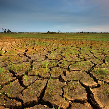
While meteorological events like hurricanes, tornadoes, and floods can cause a great deal of damage in a short period of time, droughts can be just as devastating.
A spate of recent droughts has had a major impact on farmers and ranchers in Montana, which caused a significant downturn in the state’s economy.
Previous drought prediction efforts focused mainly on rainfall, stream flow, and water storage, but they were ineffective because they ignored soil moisture. So researchers and scientists worked together to come up with a better way of predicting drought conditions.
This led to the installation of soil moisture sensors in strategic locations and at varying depths, which allowed experts to make more accurate determinations about drought conditions.
Casting the “Net”
The Montana Climate Office has created a cooperative statewide soil moisture and meteorological information system known as the Montana Mesonet.
The goals of the Montana Mesonet are to combine soil moisture and meteorological information from existing data networks, establish 100 new soil moisture recording sites, and provide a system for accessing historical, real-time, and forecasted data.
The analysis of these environmental factors helps support decision-making in agriculture, range, and forested watershed contexts. The mesonet has already made progress in these areas through the addition of new remote sites and by integrating existing networks to develop the first statewide soil-climate network.
What Is a Mesonet?
A mesonet is a network of automated weather and environmental monitoring stations designed to observe mesoscale meteorological phenomena. The term refers to the collective group of stations that are typically owned and operated by a common entity.
Weather phenomena including dry lines, squall lines, and sea breezes can be observed by mesonets. They typically record surface weather observations, but they also can involve other observation platforms like vertical profiles of the planetary boundary layer.
Working Together
The Montana Climate Office coordinates the state’s mesonet and its partnerships with a number of environmental, agricultural, and educational institutions across the state.
The partnerships are aimed at developing an integrated climate-soil water monitoring network throughout Montana to serve the agriculture economy and improve drought resilience.
The groups are expected to work together to support the 56 monitoring stations currently in place and identify locations where additional monitoring could be needed.
A View from Above
While the information collected from the underground soil sensors has been invaluable, the Montana Mesonet could soon be getting data from a more celestial source.
Microwave observations from NASA’s Soil Moisture Active Passive Mission satellite can provide statewide remotely sensed soil moisture information. The technology works on the principle that moisture in the soil changes how much incident microwave energy is reflected from Earth’s surface.
The satellite’s detection of the development of extreme soil moisture deficits and vegetation impacts during Montana’s 2017 Flash Drought proved the system’s ability to provide early warning of emerging drought conditions. Actual ground data from Montana Mesonet stations helped verify the accuracy of the satellite system measurements.
National Network
While Montana’s recent efforts — and subsequent successes — have put the state at the forefront of the mesonet conversation, other states have instituted similar programs. In fact, there’s a National Mesonet Program that has a mission of ensuring a weather-ready nation and delivering critical information that’s vital to improving weather prediction and warning systems across the country.
Origin Story
The idea of creating a National Mesonet took root in 2006 when the Congressional UrbaNet Program began leveraging existing local weather tracking stations that report near real-time observations to better assess and respond to potential hazards and incidents in U.S. metropolitan areas.
Since that time, the National Mesonet Program has grown to become a Program of Record within the National Oceanic and Atmospheric Administration’s National Weather Service, using surface networks, mobile observations, and remote sensing data to improve forecasts and support critical decisions made daily across the country.
What Happens Next?
In the coming years, the Montana Climate Office will be developing user-guided applications and web-interface tools that use soil moisture and weather information to help farmers, ranchers, and other resource managers make critical decisions.
Knowing that plant-available water is approaching critical minimum values, ranchers will be able to make arrangements to purchase hay or move or sell cattle early, before prices drop.
Additionally, government agencies can obtain a clearer picture of drought effects in the state and target relief efforts accordingly. More accurate weather and soil moisture information can result in statewide savings of several million dollars each year.
